In the field of land surveying constraint edges are maybe better known as “breaklines”. Similarly to the 2D case you can insert them into the triangle mesh, forcing segment subdivision or not. In addition you can insert a segment with its original height or you can adjust its height to the triangulation. This results in the four possibilities:
- A breakline is inserted at its original elevation
- It is inserted at its original elevation and subdivided
- A breakline is projected to the surface and then it is inserted
- Or it is projected to the surface, then it is subdivided and inserted (this is most likely what you want)
Breakline insertion at breakline elevation
The first two methods pose the simplest case because they just insert the breaklines at their own elevation:
// 2: Insert breaklines (with subdivision, no drape)
void terrain_breaklines_withSubdiv_noDraping()
{
	// * 1 *   Create a surface and some segments
	Fade_2D dt;
	createTriangulation(dt);
    vector<Segment2> vSegments;
    createCircularPolygon(vSegments);

	// * 2 *   Insert the segments ('breaklines')
    bool bOrientedSegments(false); // Not required for this demo
    bool bUseHeightOfLatest(true); // When a constraint crosses an existing one, the split point gets z from the last inserted constraint if true
    ConstraintGraph2* pCG=dt.createConstraint(vSegments,CIS_CONSTRAINED_DELAUNAY,bOrientedSegments,bUseHeightOfLatest);
    double minLen(0.1);
    pCG->makeDelaunay(minLen); // Subdivision

	// * 3 *   Visualize
	Visualizer3 vis("c2_terrain_withSubdiv_noDraping.list"); // For the Geomview viewer (Linux)
	dt.showGeomview(&vis,Visualizer3::CWHEAT);
	vis.writeSegments(vSegments,"0 0 1 0.5",true);
	dt.show("c2_terrain_withSubdiv_noDraping.ps"); // Postscript for gv, gsview or online ps-viewers
}- Step 1 creates a triangulation and a vector of line segments.
- Then the second step calls
Fade_2D::createConstraint()to insert the segments as breaklines. OptionallymakeDelaunay()can be called to subdivide the segments.
“The
makeDelaunay()method subdivides line segments until all sub-edges satisfy the empty cirlce property. This property is probably more useful in combination with breakline-insertion at surface elevation further below.”
“Any
point(x,y)has exactly one heightz. When you insert a breakline that conflicts with existing vertices or breaklines then the height of existing elements has higher priority. However, you can change this behavior usingbUseHeightOfLatest=truelike shown in the above source code.
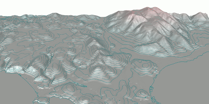
Breaklines at surface elevation
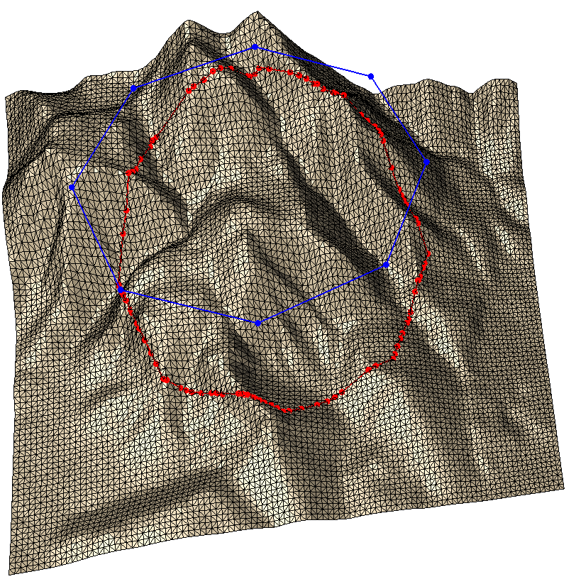
We want to insert breaklines (blue) at surface elevation (red). For this purpose we need one preparatory function call: We drape the segments (blue) onto the surface (red).
// 3: Insert breaklines (with subdivision, with drape)
void terrain_breaklines_withSubdiv_withDraping()
{
    ...
    // * 2 *   Insert the segments ('breaklines')
	double zTolerance(.1);
	vector<Segment2> vDrapedSegments;
	dt.drape(vSegments,vDrapedSegments,zTolerance);
	ConstraintGraph2* pCG=dt.createConstraint(vDrapedSegments,CIS_CONSTRAINED_DELAUNAY);
	double minLen(0.1);
	pCG->makeDelaunay(minLen); // Subdivision
    ...
}
In the above code Fade_2D::drape() drapes the original segments onto the triangulation. But this could require a large number of subdivisions. For this reason we use zTolerance>0 to reduce the number of subdivisions i.e., to subdivide a segment only if required to keep this distance to the surface. In contrast we could also use zTolerance=-1 to split the original segments at all intersections with triangulation edges. Finally we insert the draped segments into the TIN using Fade_2D::createConstraint() as before.
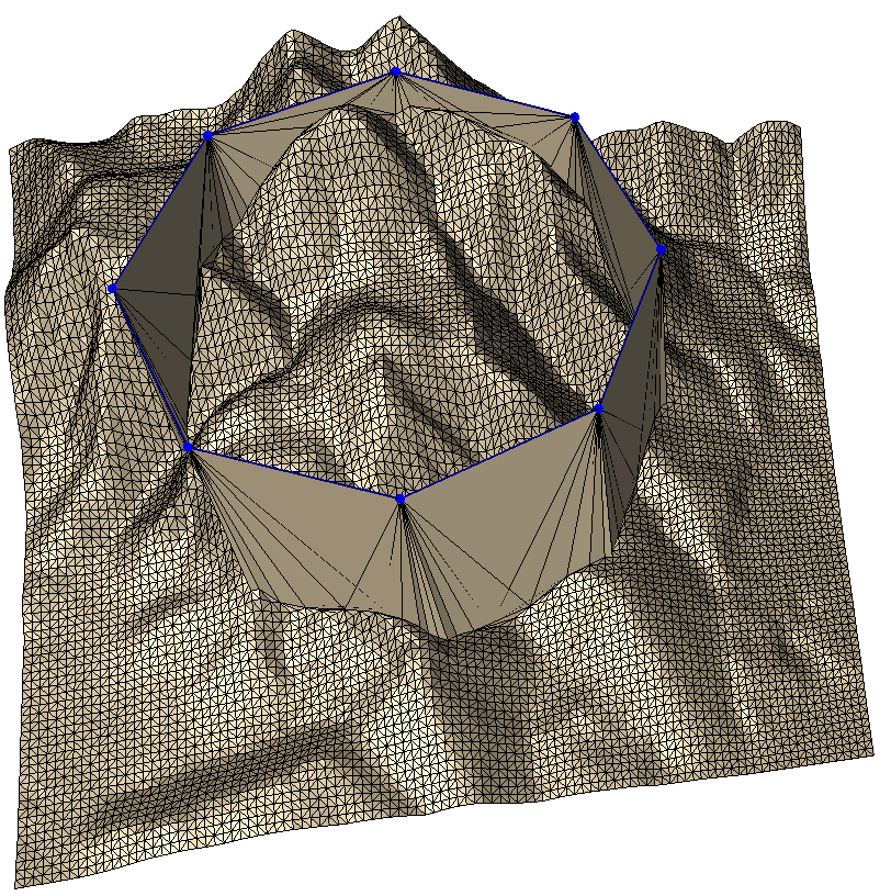
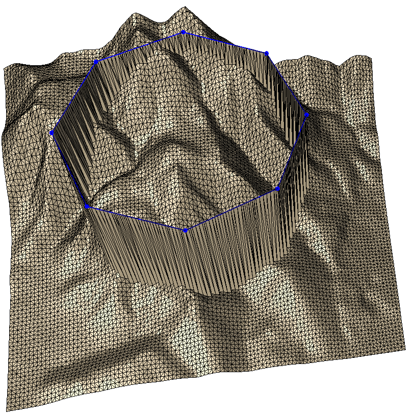
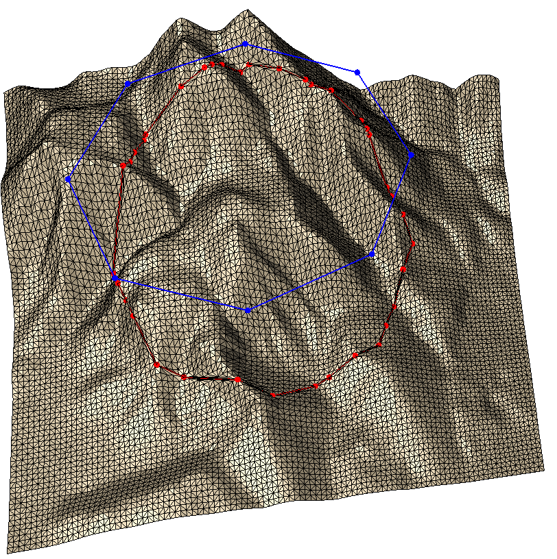
The Cookie Cutter
An often required function is the cutting of triangle meshes. You can do this with the above described breaklines, but for convenience a separate function is available, with which you can easily cut out parts of a mesh like with a cookie cutter. Have a look at the below code snippet:
// 4: Cookie Cutter
void cookieCutter()
{
// * 1 * Create a surface and a polygon
Fade_2D dt;
createTriangulation(dt);
vector<Segment2> vPolygon;
createCircularPolygon(vPolygon);
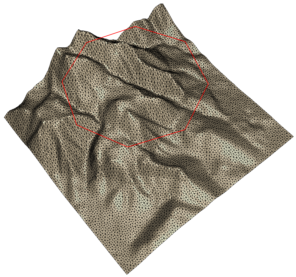
// * 2 * Show the triangulation and the polygon
Visualizer3 vis("c4_surface.list");
Zone2* pGlobalZone(dt.createZone(NULL,ZL_GLOBAL));
pGlobalZone->showGeomview(&vis,Visualizer3::CWHEAT);
vis.writeSegments(vPolygon,Visualizer3::CRED);
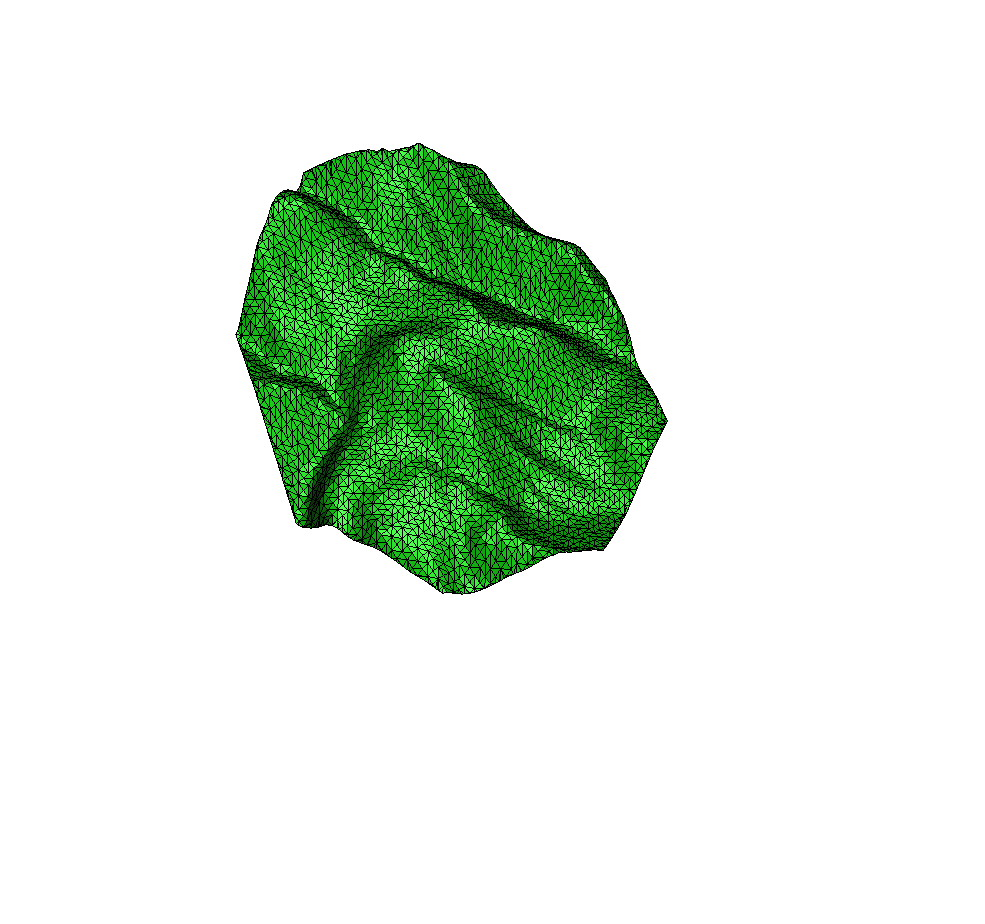
// * 3 * Cut out a piece with the cookieCutter
Zone2* pCookie(dt.createZone_cookieCutter(vPolygon,true));
pCookie->showGeomview("c4_cookie.list",Visualizer3::CGREEN);
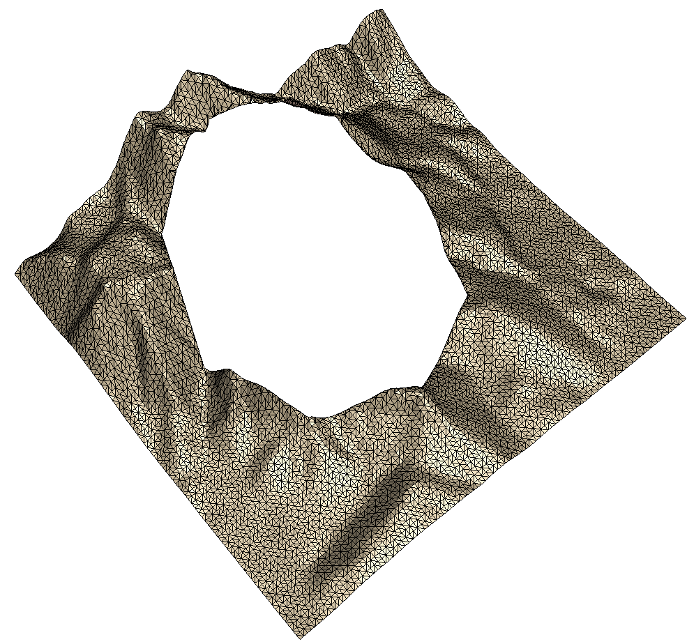
// * 4 * Compute also the complementary piece
Zone2* pNotCookie(zoneDifference(pGlobalZone,pCookie));
pNotCookie->showGeomview("c4_notCookie.list",Visualizer3::CWHEAT);
// * 5 * Save the triangulation and the zones to a file
vector<Zone2*> vSaveZones;
vSaveZones.push_back(pCookie);
vSaveZones.push_back(pNotCookie);
bool bSaveOK(false);
std::ofstream file("c4_triangulation.fade",std::ios::binary);
if(file.is_open())
{
// Use a filename or std::ostream as first argument
bSaveOK=dt.saveTriangulation(file,vSaveZones);
file.close();
}
if(!bSaveOK)
{
cout<<"File not written"<<endl;
return;
}
// * 6 * Load the triangulation from the file
Fade_2D dt2;
vector<Zone2*> vLoadZones;
bool bLoadOK=dt2.load("c4_triangulation.fade",vLoadZones); // istream works also
if(!bLoadOK)
{
cout<<"File not loaded"<<endl;
return;
}
for(size_t i=0;i<vLoadZones.size();++i)
{
Zone2* pZone(vLoadZones[i]);
string name("c4_reloadZone_"+toString(i)+".ps");
pZone->show(name.c_str(),true,false);
}
}
- Step 1 creates a triangulation (the stored mountain). Then it creates a circular polygon consisting of a few
Segment2objects - The second step creates a
Zone2* pGlobalZoneconsisting of all triangles. Then it visualizes this zone along with the segments from Step 1. - The third step creates the zone
pCookieusing the polygon as parameter for the methodcreateZone_cookieCutter(). - Step 4 uses the boolean operation
zoneDifference()to create also a zonepNotCookieconsisting of the complementary set of triangles. You might review Polygon Clipping, Boolean Operations – Example5. - Step 5 saves the triangulation and the two zones pCookie and pNotCookie using
Fade_2D::saveTriangulation(). You may refer to Saving and Loading a Triangulation for details. - Finally Step 6 reloads the stored triangulation using
Fade_2D::load()and it draws the two zones.
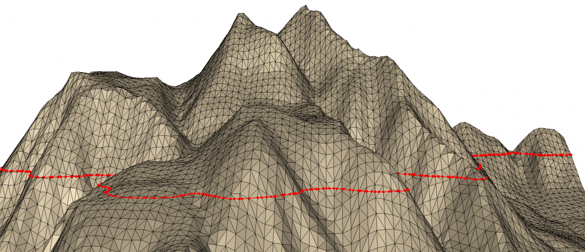
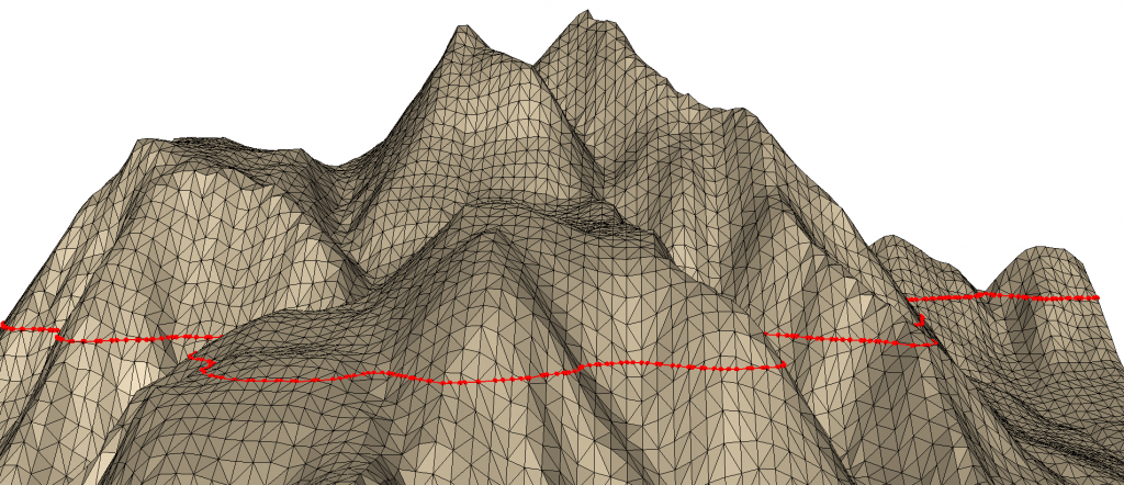
ISO contour computation
Iso contours are lines consisting of the intersection of a terrain with a horizontal plane at a certain height i.e., at a certain z-value. Fade has an exceptionally fast algorithm to calculate iso lines. We use it like this:
- Create a triangulation and fetch the triangles in
vTriangles - Create
IsoContours icoc(vTriangles) - Call
isoc.getContours(), the parameters are the query-heightas well as avectorofvector<Segment2>which is used to return the polylines.
// 5: Compute ISO lines (intersection with a horizontal plane)
void isoContours()
{
	// * 1 *   Create a surface and fetch the triangles
	Fade_2D dt;
	createTriangulation(dt);
	std::vector<Triangle2*> vTriangles;
	dt.getTrianglePointers(vTriangles);

    // * 2 *   Create IsoContours isoc
    IsoContours isoc(vTriangles);
    double minZ(isoc.getMinHeight());
    double maxZ(isoc.getMaxHeight());
    double height(minZ+0.45*(maxZ-minZ));

	// * 3 *   Compute the contours
	std::vector<std::vector<Segment2> > vvContours;
	isoc.getContours(height,vvContours,true,true);
	cout<<vvContours.size()<<"polylines at height "<<height<<endl;

    // Write the result
	for(size_t i=0;i<vvContours.size();++i)
	{
		std::vector<Segment2>& vContour(vvContours[i]);
		cout<<"\nContour no. "<<i<<" consists of "<<vContour.size()<<" segments"<<std::endl;
		vis.writeSegments(vContour,"1 0 0 0.5",true);
		for(size_t i=0;i<vContour.size();++i)
		{
			cout<<vContour[i]<<endl;
		}
    }
}
Height queries
Fade2.5D supports fast 2.5D height queries with arbitrary (x,y) coordinate pairs. The method bool getHeight(x,y,z,...) locates the triangle that contains (x,y) and finds the height value z of the point. If (x,y) is outside the triangulation then z is not set and the method returns false.
// 6: Find the height at arbitrary (x,y) coordinates
void heightQueries()
{
	// * 1 *   Create a surface and fetch the triangles
	Fade_2D dt;
	createTriangulation(dt);

	// * 2 *   Retrieve the height values at arbitrary (x,y) coordinates
	for(int i=0;i<10;++i)
	{
		double x((100.0*rand())/RAND_MAX);
		double y((100.0*rand())/RAND_MAX);
		double z;
		bool bHaveHeight(dt.getHeight(x,y,z));
		if(bHaveHeight)
		{
			cout<<"x="<<x<<", y="<<y<<", z="<<z<<endl;
		}
		else
		{
			cout<<"x="<<x<<", y="<<y<<" is out of bounds"<<endl;
		}
	}
}
* Height Queries

x=15.6679, y=40.0944, z=27.2008

x=12.979, y=10.8809, z=15.9557

x=99.8925, y=21.8257, z=17.4128

x=51.2932, y=83.9112, z=64.6294

x=61.264, y=29.6032, z=23.9884

x=63.7552, y=52.4287, z=35.941

x=49.3583, y=97.2775 is out of bounds

x=29.2517, y=77.1358, z=52.2147

x=52.6745, y=76.9914, z=55.0812

x=40.0229, y=89.1529 is out of bounds
“The
getHeight()method accepts two optional parameters: First you can useTriangle2* pApproxTto speed up the point location if you happen to know a nearby triangle. Second, use thetoleranceparameter to calculate a height even if the query-point is slightly out of bounds, as it can happen due to rounding errors.”